- Vehicles
- Passenger cars
- Estate
- Electric
- 4x4 SUVs
- Suzuki Jimny 4x4
- Dacia Duster 4x4
- Suzuki Vitara 4x4
- Suzuki Vitara auto 4x4
- Dacia Bigster 4x4
- Kia Sportage 4x4 Auto
- Kia Sportage PHEV 4x4 auto
- Mitsubishi Outlander PHEV 4x4 auto
- Toyota Rav4 4x4
- Toyota Rav4 4x4 auto
- Kia Sorento 4x4 auto
- Toyota Landcruiser 150 4x4 auto
- Toyota Landcruiser 250 4x4 auto
- Landrover Discovery 5 4x4 auto
- Landrover Defender 4x4 auto
- Prestige
- Minivans
- 4x4 Camper
- Motorhomes
- Driving in Iceland
- Services
- Locations
- Travel Inspiration
- South Iceland: A complete guide
- Reynisfjara Beach in Iceland - Your Guide to a Safe Visit
- Best Times to Visit the Golden Circle in Iceland
- North Iceland: A Complete Guide for Drivers
- East Iceland A Complete Guide for Drivers
- West Iceland The Complete Driver’s Guide
- Your Ultimate Guide to Exploring Iceland’s Ring Road
- Driving the Diamond Circle in Iceland: Your Ultimate Guide
- Driving Iceland's Golden Circle: Your Ultimate Guide
- A 10-Day Itinerary in Iceland: Tips + Ideas
- The Perfect Itinerary for 7 Days in Iceland
- The Best Time to See the Northern Lights in Iceland with a Rental Car
- Renting a Camper in Iceland: The Complete Guide
- Getting to Iceland: A Comprehensive Guide on How to Reach the Land of Fire and Ice
- Nature Bath Locations in Iceland: A Complete Guide
- Iceland with Kids: A 5-Day Self-Drive Itinerary
- Winter Driving in Iceland: A Comprehensive Overview for Foreign Tourists
- The Total Solar Eclipse in Iceland – August 12, 2026
- Exploring Iceland's National Parks on a Self-Drive Adventure
- Exploring Iceland's Wonders: A Comprehensive Guide to Activities and Car Rentals
- Springtime in Iceland – Your Comprehensive Travel Guide
- Exploring Iceland's Most Popular Highland Routes
- The Pearls of Westfjords: The Ultimate Guide
- Exploring Iceland's Hidden Gems | Off-the-Beaten-Path Adventures
- Driving in Iceland in June: Tips for a Safe and Scenic Summer Road Trip
- Driving in Iceland in July: Tips, Routes & Rentals
- Driving in Iceland in August: Late-Summer Freedom on the Open Road
- Guide to Skaftafell Iceland Self-Drive A Journey Through Fire and Ice
- Eco-Friendly Road Trips in Iceland, Sustainable Travel Tips
- Photographer’s Paradise Top Scenic Drives in Iceland for Stunning Shots
- Iceland's Folklore and Legends A Road Trip Through Mythical Sites
- Iceland’s Midnight Sun and How to Make the Most of 24-Hour Daylight
- Exploring Iceland’s Viking Heritage: Top Historical Sites
- Chasing Waterfalls: A Road Trip to Iceland’s Most Spectacular Cascades
- Iceland's Volcanic Wonders: A Self-Drive Tour of Active and Dormant Volcanoes
- Tee Off in the Land of Fire and Ice: A Guide to Golfing in Iceland
- Birdwatching in Iceland: Puffins and Beyond
- Iceland’s Diverse Beaches: Beyond the Black Sands
- Icelandic Horses: The Unique Breed of the North
- Beyond the Ring Road: Iceland’s Hidden Scenic Drives
- Iceland’s Ice Caves: A Year-Round Adventure
- Wildlife Watching in Iceland: Where and When to Go
- Iceland’s Hidden Hot Springs: A Self-Drive Guide to Secret Soaks
- Navigating Iceland’s Weather: What to Expect Each Season
- Tröllaskagi Peninsula: Iceland’s Mountainous Marvel — A Scenic Road Trip with Höldur
- Mastering Iceland's Roundabouts: A Driver’s Guide
- Essential Tips for Renting a Car in Iceland
- Navigating Iceland’s One-Lane Bridges: Your Guide to Safe and Scenic Crossings
- Exploring Iceland’s Film Locations by Rental Car
- 5 Must-Visit Destinations Within Two Hours of Keflavík Airport
- Seasonal Car Rental Tips for Iceland’s Summer Festivals
- Understanding Iceland's F-Roads: How to Drive Safely Into the Highlands
- What Makes Iceland Unique: Top 15 Highlights for an Unforgettable Journey
- Driving and Hiking in Harmony: Explore Iceland's Natural Wonders with Höldur Car Rental
- Best Car to Rent in Iceland?
- Avoiding Common Car Rental Mistakes in Iceland
- Making Your Car Rental in Iceland Child-Friendly: Tips for Stress-Free Family Travel
- Exploring Akureyri, Iceland’s Northern Gem, with EasyJet and Europcar
- Renting a Manual or Automatic Car in Iceland
- Discover the Arctic Coast Way in Iceland with Höldur Car Rental
- How to Save on Fuel Costs During Your Iceland Road Trip
- Electric vs. 4x4 Rentals in Iceland: Which is Right for Your Trip?
- Top Scenic Detours Off Iceland's Ring Road
- Top Safety Tips for First-Time Drivers on Iceland’s Roads
- Cultural Pit Stops Along Iceland’s Ring Road
- Your Guide to Exploring Stuðlagil Canyon by Car: Iceland’s Basalt Beauty Awaits
- Day Trip Ideas From Reykjavik by Rental Car
- Visit Glymur Waterfall: The Ultimate Self-Drive Adventure from Reykjavík
- Discover the Volcanic Wonders of Lake Mývatn by Car
- Discovering the Magic of Snæfellsnes Peninsula by Car
- Your Self‑Drive Guide to Gullfoss Waterfall
- A Guide to Seljalandsfoss Waterfall in Iceland: Explore by Car
- Exploring Reykjanes Peninsula A Self Drive Guide
- Exploring Iceland Landmannalaugar by 4x4
- A Beginner's Guide to River Crossings in Iceland
- Best Car Rental Offers for Iceland’s Summer Adventures
- Your Self‑Drive Guide to Þingvellir National Park
- Your Ultimate Guide to Geysir, Iceland: All You Need to Know
- How to Pay for the Vaðlaheiðargöng Tunnel
- Your Guide to Visiting Jökulsárlón Glacier Lagoon
- The Diamond Beach in Iceland: A Sparkling Wonder Worth Visiting
- Parking fines in Iceland: how to pay and what to do if you receive one
- Where to find overnight parking in Reykjavík: a local’s guide for travellers
- How to park for free in Reykjavík: tips to save on your Iceland trip
- How to pay for parking in Reykjavík - A friendly guide for drivers in Iceland
- Game of Thrones Filming Locations in Iceland: A Self-Drive Guide
- How to Choose the Right Car Rental at Keflavík Airport
- Flying Within Iceland: Your Guide to Domestic Routes and Regional Airports
- Top 3 Must-See Attractions on Iceland's Golden Circle
- Hidden Gems Along the Golden Circle Route
- Your Essential Guide to Iceland: Currency, Culture, and Car Rental Tips
- How to Plan the Perfect Golden Circle Self-Drive Tour
- The Comprehensive Guide to Rental Car Sizes at Keflavik Airport
- Húsafell & Hallmundarhraun: Hidden Lava Field Adventures by Car
- Iceland Weather by Month: What to Expect and How to Drive Safely with Holdur Car Rental
- A Guide to Iceland’s Quirky Roadside Attractions
- Exploring Iceland’s Lava Tubes | Self-Drive Cave Adventures with Höldur Car Rental
- Coolcation in Iceland: Self-Drive Your Summer Escape to the North
- Driving Iceland’s Coastal Roads: A Guide to Lesser-Known Peninsulas
- Top Tips for Driving in Iceland Safely Year-Round
- The Best Rest Stops and Viewpoints Along Iceland's Ring Road
- Driving in Iceland in September: Embrace the Autumn Adventure
- Your Guide to Exploring Fjaðrárgljúfur – South Iceland’s Fairytale Canyon
- Explore Reykholt on a Self-Drive Tour in Iceland
- How to Choose the Right Insurance for Your Iceland Car Rental
- Hiking Múlagljúfur Canyon: Iceland’s Hidden Gem You Can’t Miss
- Understanding Iceland's Weather and How It Affects Driving Conditions
- Dyrhólaey: A Complete Self-Drive Guide to Iceland's Breathtaking South Coast
- Where to See Iceland’s Tectonic Plates Up Close
- Scenic Journey on Kjalvegur Road 35 Reykjavik to Akureyri
- Guide to Visiting Svartifoss with a Rental Car
- Kerið Crater Lake in Iceland: A Self-Drive Guide
- Your Complete Guide to Stokksnes, Iceland with a Rental Car
- Hengifoss Waterfall in Iceland: The Ultimate Self-Drive Guide
- Your Complete Guide to Visiting Skógafoss Waterfall with a Rental Car
- Into the Heart of Þórsmörk: Iceland’s Valley of Thunder
- Dynjandi Waterfall in Iceland: The Ultimate Self-Drive Guide
- Visiting Ásbyrgi Canyon in North Iceland by Car: A Complete Self-Drive Guide
- Driving in Iceland in October: Embrace the Autumn Transition
- Hraunfossar: Iceland’s Hidden Gem for Self-Drive Travellers
- Barnafoss Waterfall: Iceland’s Raging Cascade with a Legend
- Driving in Iceland in November: Your Complete Guide to a Spectacular Autumn Adventure
- Fishing in Iceland: All You Need to Know
- Öxarárfoss Waterfall in Iceland: A Self-Drive Guide with Höldur
- Life in Iceland: Essential Guide to Living in the Land of Fire and Ice
- People of Iceland - 12 Fun Facts About Icelanders
- Glaumbær Turf Houses: A Self-Drive Guide to Iceland’s Living History
- Húsavík: Whale Watching Capital of Iceland
- Svínafellsjökull Glacier: A Self-Drive Guide to Iceland’s Ice Giants
- Kirkjubæjarklaustur: A Historic South Coast Gem
- Vík í Mýrdal: South Iceland’s Coastal Treasure
- Namaskard: A Self-Drive Guide to Iceland’s Geothermal Wonderland
- Laufás Heritage Site: Where Iceland’s Past Lives On
- Navigating Iceland's Gravel Roads: Tips for a Safe and Smooth Drive
- Iceland's Best Stargazing Spots for Self-Drive Travellers
- Iceland's Best Picnic Spots: Scenic Stops for Self-Drive Adventures
- Top 5 Family-Friendly Hiking Trails Accessible by Rental Car
- 15 Tips for Travelling to Iceland
- How to Plan a Winter Photography Road Trip in Iceland
- Visiting Gljúfrabúi Waterfall — A Self-Drive Guide
- How to Spot Puffins in Iceland: A Self-Drive Adventure
- Your Essential Guide to Winter Tyres and Safe Driving in Iceland
- Iceland’s Most Active Volcanoes: A Self-Drive Guide
- Iceland’s Most Scenic Bridges and River Crossings: A Self-Drive Guide
- Iceland’s Most Instagrammable Spots for Self-Drive Travellers
- How Cold Is It in Iceland During Winter? A Self-Drive Guide
- Explore Dimmuborgir: A Self-Drive Guide to Iceland's Dark Castles
- The Ultimate Guide to Iceland’s Top 5 Waterfalls by Car
- Iceland’s Best Scenic Routes for Autumn Foliage: A Self-Drive Guide
- The Best Time to Visit Iceland for Self-Drive Travellers
- Self-Drive Adventures to Iceland’s Remote Lighthouses
- Selfoss Waterfall Self-Drive Guide: Explore Iceland Your Way
- All About the Icelandic Sheep
- Vestrahorn: A Self-Drive Guide to Iceland’s Stokksnes Peninsula
- Höfn, Iceland: The Lobster Town Self-Drive Guide
- Exploring Arnarstapi: A Self-Drive Guide
- A Guide to Iceland's Seasonal Foods for Your Road Trip
- Hverfjall Crater, Iceland: A Self-Drive Guide
- Self-Drive Guide to Visiting Askja
- A Self-Drive Guide to Visiting Kerlingarfjöll
- A Self-Drive Guide to Gunnuhver Geothermal Area
- Skriduklaustur, Iceland: A Self-Drive Guide to History & Culture
- Your Ultimate Guide to Visiting the Blue Lagoon in Iceland
- Borgarnes, Iceland: Top Things to Do & Self-Drive Guide
- A Guide to Glaciers in Iceland
- Car Rental Insurance in Iceland: What’s Usually Included, What’s Not & How to Choose
- Best Car Models for Iceland’s Terrain: Recommendations by Route
- Solo Traveller’s Guide to Self-Driving in Iceland
- Exploring Iceland’s Arctic Circle: What to See and Do
- How to Plan a Budget-Friendly Road Trip in Iceland
- The History of Iceland’s National Day: A Self-Drive Celebration
- Where to Spot Whales in Iceland: A Self-Drive Guide
- The Diamond Circle vs. The Golden Circle: Which Route is Right for You?
- Embracing a Greener Journey: Sustainability in Iceland
- Granni: A Self-Drive Guide to Iceland’s Neighboring Waterfall
- Háifoss: A Self-Drive Guide to Iceland’s Tallest Waterfall
- Iceland's Best Camping Spots for Road Trippers
- Gjáin: A Self-Drive Guide to Iceland’s Hidden Oasis
- Iceland's Hidden Waterfalls: Beyond the Tourist Trails
- Hjálparfoss: A Self-Drive Guide to Iceland’s Helping Falls
- Seasonal Self-Drive Itineraries in Iceland: What’s Open When?
- Kirkjufell: A Self-Drive Guide to Iceland’s Most Photographed Mountain
- Fjallabak Nature Reserve: A Self-Drive Guide to Iceland’s Rugged Highlands
- Hrafntinnusker: A Self-Drive and Hiking Guide to Iceland’s Obsidian Wilderness
- When to Visit Iceland: Northern Lights and Ice Caves vs. Hiking and Highland Adventures
- Visiting Laugarvatn Fontana Spa with a Rental Car: A Relaxing Icelandic Getaway
- Hvítserkur Rock: A Self-Drive Guide to Iceland’s Dragon of the North
- Skiing in Iceland: A Self-Drive Guide for Winter Adventurers
- Visiting the Mývatn Nature Baths by Car: A Self-Drive Guide
- Visiting Vök Baths in East Iceland: A Self-Drive Guide
- Visiting Skútustaðir Pseudo-Craters: A Self-Drive Guide
- Visiting Hljóðaklettar: A Self-Drive Guide on the Diamond Circle
- The Ultimate Guide to Exploring Reykjavik with a Rental Car
- Visiting Seljavallalaug: A Hidden Gem in South Iceland
- Guide to Sólheimajökull Glacier by Iceland Car Rental
- Eyjafjallajökull: Iceland’s Glacier Volcano
- Ísafjörður, Iceland: Your Ultimate Self-Drive Guide to the Westfjords
- What Continent is Iceland In? A Traveler's Guide
- Katla Volcano: A Guide to Iceland's Sleeping Giant
- The Magic of Icelandic Water: A Traveler's Guide
- A Guide to Exploring Akureyri by Rental Car
- A Self-Drive Guide to the Krafla Volcanic Region
- 12-Day Iceland Self-Drive: The Complete Itinerary
- Hekla Volcano: A Self-Drive Guide to Iceland's Gateway
- Visiting Deildartunguhver: A Self-Drive Guide to Europe’s Most Powerful Hot Spring
- Exploring Borgarfjörður: A Self-Drive Guide to West Iceland
- Exploring Stórurð: A Self-Drive and Hiking Guide to East Iceland
- Visiting the Forest Lagoon in North Iceland: A Self-Drive Guide
- Driving in Iceland in December: Embrace the Winter Wonderland
- Exploring Grábrók: A Self-Drive Guide to Iceland’s Volcanic Crater
- Exploring Látrabjarg: A Self-Drive Guide to Iceland’s Westernmost Point
- Iceland Car Hire Tips for UK Drivers: What You Need to Know
- 4-Day Iceland Winter Itinerary: The Best of the South
- Mount Mælifell: Iceland’s Emerald Volcano
- How Long to Drive Around Iceland? A Self-Drive Guide
- Driving in Iceland in January
- Exploring Djúpavík: A Self-Drive Guide to Iceland’s Remote Westfjords
- What to Wear in Iceland: Tips for Every Season
- Things to Do in Stykkishólmur: A Self-Drive Adventure Through Iceland’s Magical West
- The Secret Lagoon: Iceland’s Hidden Gem of Relaxation and Discovery
- The Silver Circle of Borgarfjörður: Your Ultimate Self-Drive Guide
- Snæfellsjökull: A Journey to Iceland’s Glacier of Legends
- Car Rental Iceland 4x4: Best 4WD Options for Your Trip
- What to See in Iceland: 20 Places You Don’t Want to Miss
- How to Prepare for an Iceland Road Trip
- Your Guide to Visiting Fagrifoss Waterfall by Car
- Exploring Stakkholtsgjá Canyon: A Self-Drive Adventure in Iceland
- Kolugljúfur Canyon: A Guide to Iceland's Hidden Gem
- Exploring Kvernufoss: A Hidden Gem in South Iceland
- Skógar Museum: A Journey Through Iceland's History
- 2 Days in Iceland: The Perfect Itinerary
- Exploring Berserkjahraun: A Self-Drive Guide to Iceland’s Lava Fields
- Driving in Iceland in February: Your Complete Guide
- Iceland Daylight Hours by Month: Planning Your Trip
- Petra’s Stone Collection: A Self-Drive Gem in East Iceland
- Iceland's New Kilometer-Based Road Tax: Everything You Need to Know
- Krýsuvíkurbjarg Cliffs: Self-Drive Guide to Iceland’s Wild Coast
- Brimketill: The Reykjanes Peninsula’s Natural Lava Pool
- Exploring Eldhraun Lava Field: A Self-Drive Guide to Iceland’s Volcanic Marvel
- Iceland 2026 Car Rental Guide
- Choosing the Best 4x4 for Iceland's Westfjords
- How Sagas and History Shape Iceland's Driving Routes
- Driving in Iceland After Dark: How to Plan Safe Evening & Night Drives
- What to Do When Roads Close in Iceland: A Traveller’s Plan B Guide
- Iceland With a 2WD Only: No‑Gravel, No F‑Road Itineraries
- Iceland Through the Windshield: Landscapes You’ll See Without Leaving the Car
- Iceland EV Road Trips Made Easy (2026 Guide)
- Iceland Speed Cameras & Fines: The 2026 Driver’s Guide for Visitors
- 24 Hours in Iceland (KEF Layover): Two Seasonal Micro-Itineraries by Car
- Self-Drive Iceland for First-Timers: A Realistic Day-by-Day Pace Guide
- The Complete Self-Drive Guide to Fjallsárlón Glacier Lagoon
- Route 60 Westfjords Road Trip: Dynjandi, Þingeyri & New Tunnels Explained
- Baldur Ferry With a Rental Car: Stykkishólmur ↔ Brjánslækur
- Iceland at Easter: 5‑Day Self‑Drive Itinerary from KEF
- Westman Islands by Rental Car + Ferry: Day Trip from the South Coast
- Reykjavík Northern Lights Pull-Outs: Safe Self-Drive Spots within 45 Minutes of the Capital
- Staying Connected: Best SIM Cards and Wi-Fi Options for Your Iceland Road Trip
- The "Gas & Go" Logistics Guide: How to Pay for Gas in Iceland Without Getting Stranded
- Iceland Wind Guide for Drivers
- Fjallsárlón vs Jökulsárlón: Which Glacier Lagoon to Visit by Car?
- Iceland Road Conditions by Region (What to Expect Beyond Weather)
- Iceland’s Best Scenic Loops
- Iceland for Everyone: Accessible Natural Wonders by Car
- Iceland’s Most Photogenic Churches: A Scenic Architectural Drive
- Driving in Iceland in March: Weather, Daylight & Safe Itineraries (2026)
- Go / No-Go: A Driver’s Playbook for Using Road.is, Veður & SafeTravel Before You Set Off
- How to Plan a 3-Day Self-Drive Adventure in Iceland’s Highlands
- Driving in Iceland in April: Weather, Daylight & Safe Itineraries
- One-Way Car Rental in Iceland: Keflavik to Akureyri
- The Arctic Henge & Langanes: Driving Northeast Iceland’s Remote Edge
- Driving in Iceland in May: Late-Spring Conditions, Puffins & Ring Road Plans
- Driving in Iceland in June: 2026 Update
- 2 Days on Iceland's South Coast: The Ideal Self-Drive Itinerary
- Iceland Road Trip Packing List by Season: What to Keep in Your Rental Car
Iceland Nature
Where to See Iceland's Tectonic Plates: A Self-Drive Guide
23.08.2025
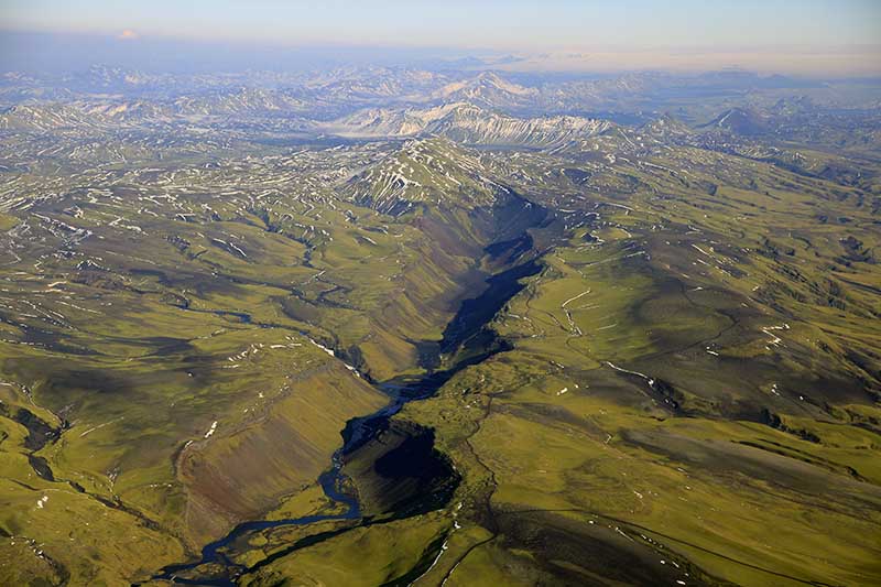
Iceland is a land of fire and ice. It is one of the few places on Earth where you can see the planet’s power with your own eyes. Here, the Mid-Atlantic Ridge rises above the ocean. This ridge separates the North American and Eurasian tectonic plates.
When you visit, you can stand right between these two massive continents. You will see deep cracks, vast lava fields, and active volcanoes.
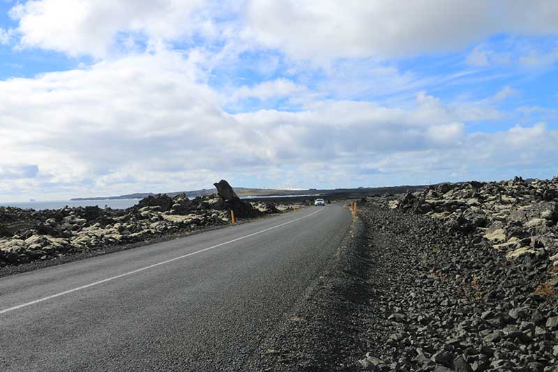
The best way to see these wonders is by car. A rental vehicle gives you the freedom to explore at your own speed. You can start your trip from Reykjavik or pick up your car at Keflavik International Airport as soon as you land. This guide helps you find the best spots to see Iceland's tectonic plates up close.
Why You Should Visit Iceland’s Tectonic Sites
Iceland sits in a unique spot on the globe. The North American and Eurasian plates are pulling apart here. They move away from each other at a rate of about 2.5 centimetres (1 inch) every year.
This movement is what created Iceland. It is the engine behind the country’s dramatic landscape. As the plates separate, they create rifts and cracks in the ground. Molten rock rises from deep within the earth to fill these gaps. This process creates:
- Volcanoes
- Hot springs
- Earthquakes
- New land
Seeing this process is not just for scientists. It is a chance to connect with nature. When you stand in a rift valley, you are standing on a planet that is alive and changing. For drivers, these sites offer incredible views and great photo opportunities. It turns a standard road trip into a journey through geological time.
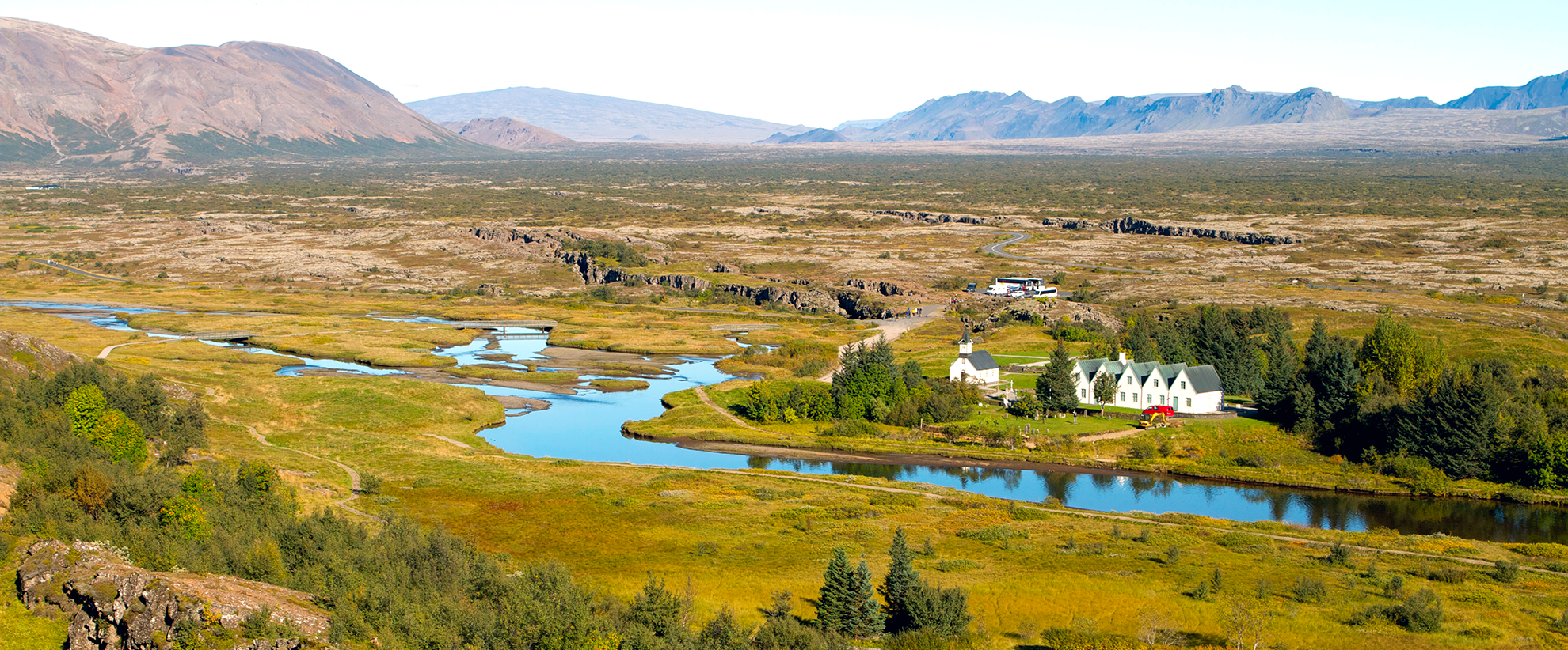
Thingvellir National Park: The Crown Jewel
Thingvellir National Park is the most famous place to see the plates. It is a UNESCO World Heritage Site because of its history and geology. It is located about 45 kilometres (28 miles) northeast of Reykjavik.
This is the most accessible place to see the Mid-Atlantic Ridge. The park sits directly in the valley between the two plates.
Getting There:
The drive from Reykjavik takes about 45 minutes. The roads are paved and well-maintained. You will drive along a scenic route with views of Lake Thingvallavatn, Iceland's largest natural lake. Having a rental car allows you to stop at viewpoints along the way.
The Almanna Gorge
The main attraction at Thingvellir is the Almanna Gorge. This is a massive cliff wall. It marks the edge of the North American plate.
When you walk along the path in the gorge, you are walking on the North American continent. You can look across the valley to see the Eurasian continent. The rock walls rise up to 40 metres (131 feet) high. They are made of basalt, a type of volcanic rock.
The valley floor widens by about 2 centimetres every year. New cracks appear often. There are over 100 fissures in the park. Each one shows where the earth has split apart.
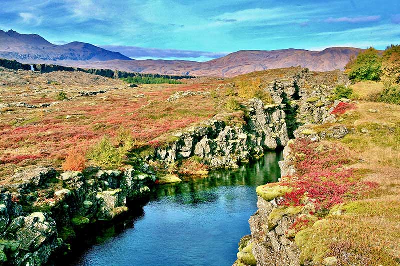
Snorkelling at Silfra Fissure
Thingvellir is also home to the Silfra Fissure. This is a deep crack filled with crystal-clear water. The water comes from a glacier and is filtered through lava rocks for decades.
- Visibility: You can see over 100 metres underwater.
- Temperature: The water is cold, staying at 2-4°C (35-39°F) all year.
- Experience: You can snorkel or dive right between the continents.
At Silfra, you are literally floating between North America and Europe. You can almost touch both plates at the same time. Note that you need to book a tour with a certified guide to enter the water. However, having your own car helps you get to the meeting point on time.
Facilities at Thingvellir
The park is very visitor-friendly. It has:
- A visitor centre with exhibits about geology.
- Multiple parking lots for cars and campers.
- Marked walking paths and viewing platforms.
- Restrooms and a cafe.
Entry to the park is free, but you must pay a small fee for parking. The park is open all year. In winter, the snow contrasts beautifully with the black lava rocks.
The Reykjanes Peninsula: Where Fire Meets the Ocean
If you want to start your adventure immediately, head to the Reykjanes Peninsula. This area is located southwest of Reykjavik, near the international airport.
The landscape here looks like another planet. It is raw and rugged. The Mid-Atlantic Ridge runs right through the peninsula before disappearing into the sea. This area is very active. Recent volcanic eruptions near Fagradalsfjall show that the earth is still moving here.
Bridge Between Continents
One of the best stops is the "Bridge Between Continents." This is a small footbridge near the town of Grindavik. It spans a large fissure in the earth.
- The Walk: You can walk from the North American plate to the Eurasian plate in seconds.
- The Symbol: The bridge represents the connection between the two landmasses.
- The Signs: There are signs welcoming you to "America" and "Europe."
This site is easy to reach by car. It has a parking lot and is a short walk from the road. It is a great spot for a quick photo.
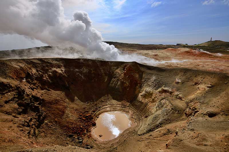
Gunnuhver Geothermal Area
Nearby, you can visit r. This is a powerful geothermal field. It is named after a legendary ghost.
Here, you can see the hea Gunnuhver from the tectonic movement. The magma underground heats the water, creating:
- Bubbling mud pools
- Steaming vents
- Colorful mineral deposits
The steam here can be very thick. Wooden walkways allow you to walk safely through the steam. It is a powerful reminder of the heat beneath your feet.
The Krafla Volcanic System: The Northern Powerhouse
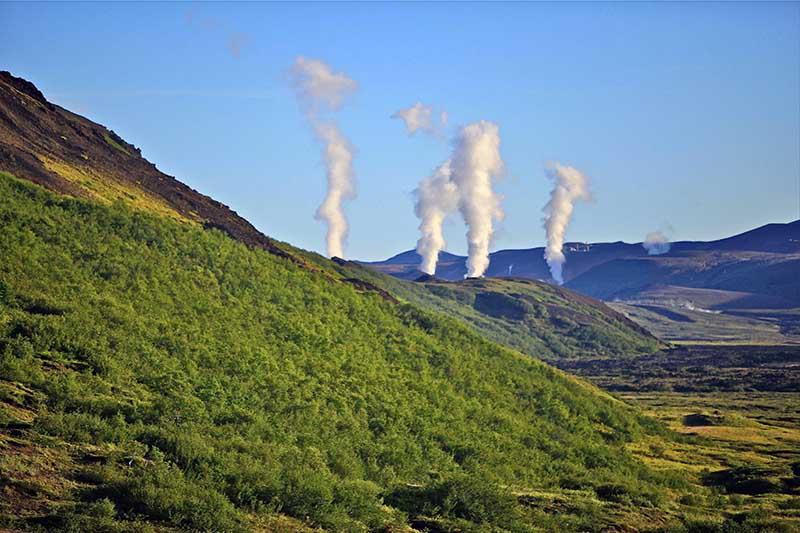
If you are driving the Ring Road to North Iceland, you must visit Krafla. This area is near Lake Myvatn. It offers a different view of tectonic activity.
Krafla is a very active volcanic area. It sits on the northern part of the ridge. The ground here has shifted many times in history.
Leirhnjukur Lava Fields
Leirhnjukur is a fascinating place to hike. You can walk through lava fields that are still warm in places. The lava here is relatively young. It was formed during eruptions in the 1970s and 1980s.
The black lava creates strange shapes. The ground is colorful due to sulfur and other minerals. It is an easy hike from the parking lot. Just make sure to stay on the marked trails for safety.
Viti Crater
Close to Leirhnjukur is the Viti Crater. The name means "Hell" in Icelandic. It was formed by a huge explosion in 1724.
Today, the crater is filled with blue-green water. It is a stunning sight. You can walk around the rim of the crater to see the lake inside. This crater shows the explosive power of the tectonic plates.
Eldgjá: The Highland Giant
For adventurous drivers, Eldgjá is a must-see. It is located in the southern highlands. Eldgjá is the largest volcanic canyon in the world.
This massive fissure is 75 kilometres (47 miles) long. It was created by a massive eruption over 1,000 years ago.
Important Note: To reach Eldgjá, you need a 4x4 vehicle. The roads are rough (F-roads) and involve river crossings. This trip is best for confident drivers.
The scale of Eldgjá is hard to imagine until you are there. You can hike into the canyon to see the waterfalls and rock walls. It is a quieter, more remote experience than Thingvellir.
Planning Your Road Trip
Seeing the tectonic plates is easy with a rental car. Here are some tips to help you plan.
Frequently Asked Questions
What kind of car do I need?
- Standard Car: A regular car is fine for Thingvellir, the Reykjanes Peninsula, and the main roads around Krafla.
- 4x4 SUV: You must have a 4x4 if you plan to visit Eldgjá or drive on highland F-roads. A 4x4 is also safer for winter driving.
When is the best time to visit?
You can visit these sites all year round.
- Summer: The days are long, and all roads are open.
- Winter: The landscape is covered in snow, which is beautiful. However, you must drive carefully. Roads to the highlands (like Eldgjá) are closed in winter.
Do I need special gear?
You do not need technical gear for most sites. However, you should bring:
- Sturdy, waterproof hiking boots.
- Warm layers and a waterproof jacket.
- A camera to capture the views.
How much time should I spend?
- Thingvellir: Plan for at least half a day.
- Reykjanes: This makes a great day trip from Reykjavik.
- Krafla: Plan to spend 2-3 hours exploring the area.

Conclusion
Iceland offers a rare chance to see how our world works. The forces that move continents are visible right in front of you.
From the famous cliffs of Thingvellir to the steaming grounds of Reykjanes, these sites are unforgettable. They show the raw power and beauty of nature.
Having your own vehicle makes this journey much better. A self-drive tour allows you to:
- Avoid the crowds.
- Stay as long as you like at each spot.
- Change your plans based on the weather.
- Enjoy the comfort of your own space.
Whether you are walking between continents or watching mud boil, you are witnessing the history of the Earth. It is an experience that will stay with you long after you leave.
Ready to explore? Make sure you choose the right vehicle for your journey and drive safely. The tectonic plates await you.
