- Vehicles
- Passenger cars
- Estate
- Electric
- 4x4 SUVs
- Suzuki Jimny 4x4
- Dacia Duster 4x4
- Suzuki Vitara 4x4
- Suzuki Vitara auto 4x4
- Dacia Bigster 4x4
- Kia Sportage 4x4 Auto
- Kia Sportage PHEV 4x4 auto
- Mitsubishi Outlander PHEV 4x4 auto
- Toyota Rav4 4x4
- Toyota Rav4 4x4 auto
- Kia Sorento 4x4 auto
- Toyota Landcruiser 150 4x4 auto
- Toyota Landcruiser 250 4x4 auto
- Landrover Discovery 5 4x4 auto
- Landrover Defender 4x4 auto
- Prestige
- Minivans
- 4x4 Camper
- Motorhomes
- Driving in Iceland
- Services
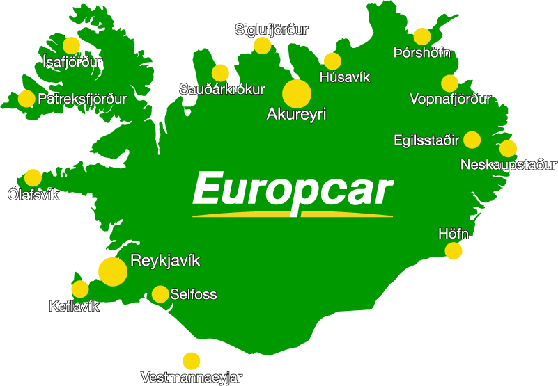
- Locations
- Travel Inspiration
- South Iceland: A complete guide
- Reynisfjara Beach in Iceland - Your Guide to a Safe Visit
- Best Times to Visit the Golden Circle in Iceland
- North Iceland: A Complete Guide for Drivers
- East Iceland A Complete Guide for Drivers
- West Iceland The Complete Driver’s Guide
- Your Ultimate Guide to Exploring Iceland’s Ring Road
- Driving the Diamond Circle in Iceland: Your Ultimate Guide
- Driving Iceland's Golden Circle: Your Ultimate Guide
- A 10-Day Itinerary in Iceland: Tips + Ideas
- The Perfect Itinerary for 7 Days in Iceland
- The Best Time to See the Northern Lights in Iceland with a Rental Car
- Renting a Camper in Iceland: The Complete Guide
- Getting to Iceland: A Comprehensive Guide on How to Reach the Land of Fire and Ice
- Nature Bath Locations in Iceland: A Complete Guide
- Iceland with Kids: A 5-Day Self-Drive Itinerary
- Winter Driving in Iceland: A Comprehensive Overview for Foreign Tourists
- The Total Solar Eclipse in Iceland – August 12, 2026
- Exploring Iceland's National Parks on a Self-Drive Adventure
- Exploring Iceland's Wonders: A Comprehensive Guide to Activities and Car Rentals
- Springtime in Iceland – Your Comprehensive Travel Guide
- Exploring Iceland's Most Popular Highland Routes
- The Pearls of Westfjords: The Ultimate Guide
- Exploring Iceland's Hidden Gems | Off-the-Beaten-Path Adventures
- Driving in Iceland in June: Tips for a Safe and Scenic Summer Road Trip
- Driving in Iceland in July: Tips, Routes & Rentals
- Driving in Iceland in August: Late-Summer Freedom on the Open Road
- Guide to Skaftafell Iceland Self-Drive A Journey Through Fire and Ice
- Eco-Friendly Road Trips in Iceland, Sustainable Travel Tips
- Photographer’s Paradise Top Scenic Drives in Iceland for Stunning Shots
- Iceland's Folklore and Legends A Road Trip Through Mythical Sites
- Iceland’s Midnight Sun and How to Make the Most of 24-Hour Daylight
- Exploring Iceland’s Viking Heritage: Top Historical Sites
- Chasing Waterfalls: A Road Trip to Iceland’s Most Spectacular Cascades
- Iceland's Volcanic Wonders: A Self-Drive Tour of Active and Dormant Volcanoes
- Tee Off in the Land of Fire and Ice: A Guide to Golfing in Iceland
- Birdwatching in Iceland: Puffins and Beyond
- Iceland’s Diverse Beaches: Beyond the Black Sands
- Icelandic Horses: The Unique Breed of the North
- Beyond the Ring Road: Iceland’s Hidden Scenic Drives
- Iceland’s Ice Caves: A Year-Round Adventure
- Wildlife Watching in Iceland: Where and When to Go
- Iceland’s Hidden Hot Springs: A Self-Drive Guide to Secret Soaks
- Navigating Iceland’s Weather: What to Expect Each Season
- Tröllaskagi Peninsula: Iceland’s Mountainous Marvel — A Scenic Road Trip with Höldur
- Mastering Iceland's Roundabouts: A Driver’s Guide
- Essential Tips for Renting a Car in Iceland
- Navigating Iceland’s One-Lane Bridges: Your Guide to Safe and Scenic Crossings
- Exploring Iceland’s Film Locations by Rental Car
- 5 Must-Visit Destinations Within Two Hours of Keflavík Airport
- Seasonal Car Rental Tips for Iceland’s Summer Festivals
- Understanding Iceland's F-Roads: How to Drive Safely Into the Highlands
- What Makes Iceland Unique: Top 15 Highlights for an Unforgettable Journey
- Driving and Hiking in Harmony: Explore Iceland's Natural Wonders with Höldur Car Rental
- Best Car to Rent in Iceland?
- Avoiding Common Car Rental Mistakes in Iceland
- Making Your Car Rental in Iceland Child-Friendly: Tips for Stress-Free Family Travel
- Exploring Akureyri, Iceland’s Northern Gem, with EasyJet and Europcar
- Renting a Manual or Automatic Car in Iceland
- Discover the Arctic Coast Way in Iceland with Höldur Car Rental
- How to Save on Fuel Costs During Your Iceland Road Trip
- Electric vs. 4x4 Rentals in Iceland: Which is Right for Your Trip?
- Top Scenic Detours Off Iceland's Ring Road
- Top Safety Tips for First-Time Drivers on Iceland’s Roads
- Cultural Pit Stops Along Iceland’s Ring Road
- Your Guide to Exploring Stuðlagil Canyon by Car: Iceland’s Basalt Beauty Awaits
- Day Trip Ideas From Reykjavik by Rental Car
- Visit Glymur Waterfall: The Ultimate Self-Drive Adventure from Reykjavík
- Discover the Volcanic Wonders of Lake Mývatn by Car
- Discovering the Magic of Snæfellsnes Peninsula by Car
- Your Self‑Drive Guide to Gullfoss Waterfall
- A Guide to Seljalandsfoss Waterfall in Iceland: Explore by Car
- Exploring Reykjanes Peninsula A Self Drive Guide
- Exploring Iceland Landmannalaugar by 4x4
- A Beginner's Guide to River Crossings in Iceland
- Best Car Rental Offers for Iceland’s Summer Adventures
- Your Self‑Drive Guide to Þingvellir National Park
- Your Ultimate Guide to Geysir, Iceland: All You Need to Know
- How to Pay for the Vaðlaheiðargöng Tunnel
- Your Guide to Visiting Jökulsárlón Glacier Lagoon
- The Diamond Beach in Iceland: A Sparkling Wonder Worth Visiting
- Parking fines in Iceland: how to pay and what to do if you receive one
- Where to find overnight parking in Reykjavík: a local’s guide for travellers
- How to park for free in Reykjavík: tips to save on your Iceland trip
- How to pay for parking in Reykjavík - A friendly guide for drivers in Iceland
- Game of Thrones Filming Locations in Iceland: A Self-Drive Guide
- How to Choose the Right Car Rental at Keflavík Airport
- Flying Within Iceland: Your Guide to Domestic Routes and Regional Airports
- Top 3 Must-See Attractions on Iceland's Golden Circle
- Hidden Gems Along the Golden Circle Route
- Your Essential Guide to Iceland: Currency, Culture, and Car Rental Tips
- How to Plan the Perfect Golden Circle Self-Drive Tour
- The Comprehensive Guide to Rental Car Sizes at Keflavik Airport
- Húsafell & Hallmundarhraun: Hidden Lava Field Adventures by Car
- Iceland Weather by Month: What to Expect and How to Drive Safely with Holdur Car Rental
- A Guide to Iceland’s Quirky Roadside Attractions
- Exploring Iceland’s Lava Tubes | Self-Drive Cave Adventures with Höldur Car Rental
- Coolcation in Iceland: Self-Drive Your Summer Escape to the North
- Driving Iceland’s Coastal Roads: A Guide to Lesser-Known Peninsulas
- Top Tips for Driving in Iceland Safely Year-Round
- The Best Rest Stops and Viewpoints Along Iceland's Ring Road
- Driving in Iceland in September: Embrace the Autumn Adventure
- Your Guide to Exploring Fjaðrárgljúfur – South Iceland’s Fairytale Canyon
- Explore Reykholt on a Self-Drive Tour in Iceland
- How to Choose the Right Insurance for Your Iceland Car Rental
- Hiking Múlagljúfur Canyon: Iceland’s Hidden Gem You Can’t Miss
- Understanding Iceland's Weather and How It Affects Driving Conditions
- Dyrhólaey: A Complete Self-Drive Guide to Iceland's Breathtaking South Coast
- Where to See Iceland’s Tectonic Plates Up Close
- Scenic Journey on Kjalvegur Road 35 Reykjavik to Akureyri
- Guide to Visiting Svartifoss with a Rental Car
- Kerið Crater Lake in Iceland: A Self-Drive Guide
- Your Complete Guide to Stokksnes, Iceland with a Rental Car
- Hengifoss Waterfall in Iceland: The Ultimate Self-Drive Guide
- Your Complete Guide to Visiting Skógafoss Waterfall with a Rental Car
- Into the Heart of Þórsmörk: Iceland’s Valley of Thunder
- Dynjandi Waterfall in Iceland: The Ultimate Self-Drive Guide
- Visiting Ásbyrgi Canyon in North Iceland by Car: A Complete Self-Drive Guide
- Driving in Iceland in October: Embrace the Autumn Transition
- Hraunfossar: Iceland’s Hidden Gem for Self-Drive Travellers
- Barnafoss Waterfall: Iceland’s Raging Cascade with a Legend
- Driving in Iceland in November: Your Complete Guide to a Spectacular Autumn Adventure
- Fishing in Iceland: All You Need to Know
- Öxarárfoss Waterfall in Iceland: A Self-Drive Guide with Höldur
- Life in Iceland: Essential Guide to Living in the Land of Fire and Ice
- People of Iceland - 12 Fun Facts About Icelanders
- Glaumbær Turf Houses: A Self-Drive Guide to Iceland’s Living History
- Húsavík: Whale Watching Capital of Iceland
- Svínafellsjökull Glacier: A Self-Drive Guide to Iceland’s Ice Giants
- Kirkjubæjarklaustur: A Historic South Coast Gem
- Vík í Mýrdal: South Iceland’s Coastal Treasure
- Namaskard: A Self-Drive Guide to Iceland’s Geothermal Wonderland
- Laufás Heritage Site: Where Iceland’s Past Lives On
- Navigating Iceland's Gravel Roads: Tips for a Safe and Smooth Drive
- Iceland's Best Stargazing Spots for Self-Drive Travellers
- Iceland's Best Picnic Spots: Scenic Stops for Self-Drive Adventures
- Top 5 Family-Friendly Hiking Trails Accessible by Rental Car
- 15 Tips for Travelling to Iceland
- How to Plan a Winter Photography Road Trip in Iceland
- Visiting Gljúfrabúi Waterfall — A Self-Drive Guide
- How to Spot Puffins in Iceland: A Self-Drive Adventure
- Your Essential Guide to Winter Tyres and Safe Driving in Iceland
- Iceland’s Most Active Volcanoes: A Self-Drive Guide
- Iceland’s Most Scenic Bridges and River Crossings: A Self-Drive Guide
- Iceland’s Most Instagrammable Spots for Self-Drive Travellers
- How Cold Is It in Iceland During Winter? A Self-Drive Guide
- Explore Dimmuborgir: A Self-Drive Guide to Iceland's Dark Castles
- The Ultimate Guide to Iceland’s Top 5 Waterfalls by Car
- Iceland’s Best Scenic Routes for Autumn Foliage: A Self-Drive Guide
- The Best Time to Visit Iceland for Self-Drive Travellers
- Self-Drive Adventures to Iceland’s Remote Lighthouses
- Selfoss Waterfall Self-Drive Guide: Explore Iceland Your Way
- All About the Icelandic Sheep
- Vestrahorn: A Self-Drive Guide to Iceland’s Stokksnes Peninsula
- Höfn, Iceland: The Lobster Town Self-Drive Guide
- Exploring Arnarstapi: A Self-Drive Guide
- A Guide to Iceland's Seasonal Foods for Your Road Trip
- Hverfjall Crater, Iceland: A Self-Drive Guide
- Self-Drive Guide to Visiting Askja
- A Self-Drive Guide to Visiting Kerlingarfjöll
- A Self-Drive Guide to Gunnuhver Geothermal Area
- Skriduklaustur, Iceland: A Self-Drive Guide to History & Culture
- Your Ultimate Guide to Visiting the Blue Lagoon in Iceland
- Borgarnes, Iceland: Top Things to Do & Self-Drive Guide
- A Guide to Glaciers in Iceland
- Car Rental Insurance in Iceland: What’s Usually Included, What’s Not & How to Choose
- Best Car Models for Iceland’s Terrain: Recommendations by Route
- Solo Traveller’s Guide to Self-Driving in Iceland
- Exploring Iceland’s Arctic Circle: What to See and Do
- How to Plan a Budget-Friendly Road Trip in Iceland
- The History of Iceland’s National Day: A Self-Drive Celebration
- Where to Spot Whales in Iceland: A Self-Drive Guide
- The Diamond Circle vs. The Golden Circle: Which Route is Right for You?
- Embracing a Greener Journey: Sustainability in Iceland
- Granni: A Self-Drive Guide to Iceland’s Neighboring Waterfall
- Háifoss: A Self-Drive Guide to Iceland’s Tallest Waterfall
- Iceland's Best Camping Spots for Road Trippers
- Gjáin: A Self-Drive Guide to Iceland’s Hidden Oasis
- Iceland's Hidden Waterfalls: Beyond the Tourist Trails
- Hjálparfoss: A Self-Drive Guide to Iceland’s Helping Falls
- Seasonal Self-Drive Itineraries in Iceland: What’s Open When?
- Kirkjufell: A Self-Drive Guide to Iceland’s Most Photographed Mountain
- Fjallabak Nature Reserve: A Self-Drive Guide to Iceland’s Rugged Highlands
- Hrafntinnusker: A Self-Drive and Hiking Guide to Iceland’s Obsidian Wilderness
- When to Visit Iceland: Northern Lights and Ice Caves vs. Hiking and Highland Adventures
- Visiting Laugarvatn Fontana Spa with a Rental Car: A Relaxing Icelandic Getaway
- Hvítserkur Rock: A Self-Drive Guide to Iceland’s Dragon of the North
- Skiing in Iceland: A Self-Drive Guide for Winter Adventurers
- Visiting the Mývatn Nature Baths by Car: A Self-Drive Guide
- Visiting Vök Baths in East Iceland: A Self-Drive Guide
- Visiting Skútustaðir Pseudo-Craters: A Self-Drive Guide
- Visiting Hljóðaklettar: A Self-Drive Guide on the Diamond Circle
- The Ultimate Guide to Exploring Reykjavik with a Rental Car
- Visiting Seljavallalaug: A Hidden Gem in South Iceland
- Guide to Sólheimajökull Glacier by Iceland Car Rental
- Eyjafjallajökull: Iceland’s Glacier Volcano
- Ísafjörður, Iceland: Your Ultimate Self-Drive Guide to the Westfjords
- What Continent is Iceland In? A Traveler's Guide
- Katla Volcano: A Guide to Iceland's Sleeping Giant
- The Magic of Icelandic Water: A Traveler's Guide
- A Guide to Exploring Akureyri by Rental Car
- A Self-Drive Guide to the Krafla Volcanic Region
- 12-Day Iceland Self-Drive: The Complete Itinerary
- Hekla Volcano: A Self-Drive Guide to Iceland's Gateway
- Visiting Deildartunguhver: A Self-Drive Guide to Europe’s Most Powerful Hot Spring
- Exploring Borgarfjörður: A Self-Drive Guide to West Iceland
- Exploring Stórurð: A Self-Drive and Hiking Guide to East Iceland
- Visiting the Forest Lagoon in North Iceland: A Self-Drive Guide
- Driving in Iceland in December: Embrace the Winter Wonderland
- Exploring Grábrók: A Self-Drive Guide to Iceland’s Volcanic Crater
- Exploring Látrabjarg: A Self-Drive Guide to Iceland’s Westernmost Point
- Iceland Car Hire Tips for UK Drivers: What You Need to Know
- 4-Day Iceland Winter Itinerary: The Best of the South
- Mount Mælifell: Iceland’s Emerald Volcano
- How Long to Drive Around Iceland? A Self-Drive Guide
- Driving in Iceland in January
- Exploring Djúpavík: A Self-Drive Guide to Iceland’s Remote Westfjords
- What to Wear in Iceland: Tips for Every Season
- Things to Do in Stykkishólmur: A Self-Drive Adventure Through Iceland’s Magical West
- The Secret Lagoon: Iceland’s Hidden Gem of Relaxation and Discovery
- The Silver Circle of Borgarfjörður: Your Ultimate Self-Drive Guide
- Snæfellsjökull: A Journey to Iceland’s Glacier of Legends
- Car Rental Iceland 4x4: Best 4WD Options for Your Trip
- What to See in Iceland: 20 Places You Don’t Want to Miss
- How to Prepare for an Iceland Road Trip
- Your Guide to Visiting Fagrifoss Waterfall by Car
- Exploring Stakkholtsgjá Canyon: A Self-Drive Adventure in Iceland
- Kolugljúfur Canyon: A Guide to Iceland's Hidden Gem
- Exploring Kvernufoss: A Hidden Gem in South Iceland
- Skógar Museum: A Journey Through Iceland's History
- 2 Days in Iceland: The Perfect Itinerary
- Exploring Berserkjahraun: A Self-Drive Guide to Iceland’s Lava Fields
- Driving in Iceland in February: Your Complete Guide
- Iceland Daylight Hours by Month: Planning Your Trip
- Petra’s Stone Collection: A Self-Drive Gem in East Iceland
- Iceland's New Kilometer-Based Road Tax: Everything You Need to Know
- Krýsuvíkurbjarg Cliffs: Self-Drive Guide to Iceland’s Wild Coast
- Brimketill: The Reykjanes Peninsula’s Natural Lava Pool
- Exploring Eldhraun Lava Field: A Self-Drive Guide to Iceland’s Volcanic Marvel
- Iceland 2026 Car Rental Guide
- Choosing the Best 4x4 for Iceland's Westfjords
- How Sagas and History Shape Iceland's Driving Routes
- Driving in Iceland After Dark: How to Plan Safe Evening & Night Drives
- What to Do When Roads Close in Iceland: A Traveller’s Plan B Guide
- Iceland With a 2WD Only: No‑Gravel, No F‑Road Itineraries
- Iceland Through the Windshield: Landscapes You’ll See Without Leaving the Car
- Iceland EV Road Trips Made Easy (2026 Guide)
- Iceland Speed Cameras & Fines: The 2026 Driver’s Guide for Visitors
- 24 Hours in Iceland (KEF Layover): Two Seasonal Micro-Itineraries by Car
- Self-Drive Iceland for First-Timers: A Realistic Day-by-Day Pace Guide
- The Complete Self-Drive Guide to Fjallsárlón Glacier Lagoon
- Route 60 Westfjords Road Trip: Dynjandi, Þingeyri & New Tunnels Explained
- Baldur Ferry With a Rental Car: Stykkishólmur ↔ Brjánslækur
- Iceland at Easter: 5‑Day Self‑Drive Itinerary from KEF
- Westman Islands by Rental Car + Ferry: Day Trip from the South Coast
- Reykjavík Northern Lights Pull-Outs: Safe Self-Drive Spots within 45 Minutes of the Capital
- Staying Connected: Best SIM Cards and Wi-Fi Options for Your Iceland Road Trip
- The "Gas & Go" Logistics Guide: How to Pay for Gas in Iceland Without Getting Stranded
- Iceland Wind Guide for Drivers
- Fjallsárlón vs Jökulsárlón: Which Glacier Lagoon to Visit by Car?
- Iceland Road Conditions by Region (What to Expect Beyond Weather)
- Iceland’s Best Scenic Loops
- Iceland for Everyone: Accessible Natural Wonders by Car
- Iceland’s Most Photogenic Churches: A Scenic Architectural Drive
- Driving in Iceland in March: Weather, Daylight & Safe Itineraries (2026)
- Go / No-Go: A Driver’s Playbook for Using Road.is, Veður & SafeTravel Before You Set Off
- How to Plan a 3-Day Self-Drive Adventure in Iceland’s Highlands
- Driving in Iceland in April: Weather, Daylight & Safe Itineraries
- One-Way Car Rental in Iceland: Keflavik to Akureyri
- The Arctic Henge & Langanes: Driving Northeast Iceland’s Remote Edge
- Driving in Iceland in May: Late-Spring Conditions, Puffins & Ring Road Plans
- Driving in Iceland in June: 2026 Update
- 2 Days on Iceland's South Coast: The Ideal Self-Drive Itinerary
- Iceland Road Trip Packing List by Season: What to Keep in Your Rental Car
Road Trip Itineraries
2 Days on Iceland's South Coast: The Ideal Self-Drive Itinerary
10.06.2026
Few stretches of road in the world pack as much geological drama into such a short distance as Iceland's Route 1 heading east from Reykjavík. Within a few hours of driving, the landscape shifts from moss-covered volcanic plateaus into towering basalt cliffs, cascading waterfalls, black sand deserts, and massive glacial tongues creeping toward the Atlantic.
For independent travelers, a self-drive journey is the definitive way to experience this region. It gives you the freedom to outrun the tour buses, linger at a hidden viewpoint, and adjust your pace when the Icelandic elements demand it. But because the South Coast is so dense with landmarks, a tight two-day window calls for strategic planning, precise logistics, and a clear understanding of what your vehicle can handle.
As Iceland's largest car rental operator, Höldur has spent decades helping travelers navigate these roads safely and comfortably. This local guide gives you an optimized 48-hour itinerary that balances iconic sights with practical driving realities, so your journey is inspiring, seamless, and secure.
Choosing Your Ride: Matching Your Vehicle to the Icelandic Seasons
Before you turn the ignition key, match your choice of vehicle to the time of year and your intended route. Iceland's infrastructure is excellent, but the North Atlantic weather is famously fickle. A car that feels perfect on a warm July afternoon can feel completely inadequate during a windy November morning.
The Summer Standard (May to September)
During the high summer months, the South Coast's main artery, the Ring Road (Route 1), is fully paved, well marked, and highly accessible. If you stick strictly to this itinerary in summer, a compact or standard two-wheel-drive (2WD) hatchback or sedan is perfectly sufficient.
Even in summer, though, an upgraded class brings clear advantages:
- Medium and large SUVs: If you are traveling with more than two large pieces of luggage, or you value a higher driving position for better sightseeing, a mid-sized SUV offers superior comfort.
- 4x4 capability: Planning to venture onto interior F-roads or gravel detours? A 4x4 is legally required on all designated F-roads and is highly recommended for unpaved secondary routes.
The Winter Reality (October to April)
Winter transforms the South Coast into a surreal wonderland of blue ice and snow-dusted volcanic peaks. It also brings sub-zero temperatures, black ice, packed snow, and gale-force crosswinds.
For winter driving along the South Coast, a four-wheel-drive (4x4) vehicle is not just recommended, it is essential for peace of mind.
- Tires and traction: At Höldur, all of our winter rentals come equipped with high-quality winter tires. Studded tires are standard during the deepest winter months to ensure maximum grip on icy asphalt.
- Ground clearance: A 4x4 SUV gives you the clearance to safely handle unexpected snow drifts or slushy parking lots.
- Wind resistance: Larger, heavier 4x4 vehicles handle the South Coast's notorious wind gusts with far greater stability than lightweight economy cars.
Learn all about winter driving here: Winter Car Rental in Iceland.
Day 1: Waterfalls, Basalt Columns, and the Gateway to the South
Morning: Departing Reykjavík and Navigating the Volcano Towns
Drive distance: about 130 km (Reykjavík to Seljalandsfoss)
Estimated drive time: 1 hour 45 minutes
Your journey begins when you pick up your vehicle at our Reykjavík city office or directly from Keflavík International Airport. Leaving the capital, you head east on Route 1, climbing through the steaming geothermal fields of Hellisheiði. On a clear day, the views across the plains toward the southern lowlands are spectacular.
Your first major waypoint is the town of Hveragerði, famous for its geothermal greenhouses, followed by Selfoss, the commercial hub of the south. Selfoss is the ideal spot to stop at a local supermarket and stock up on road-trip snacks, water, and coffee.
Local driving tip: As you leave Selfoss, the road opens into a long, straight stretch flanked by wide-open pastures. Keep a steady eye on your speedometer. The standard speed limit on paved rural roads in Iceland is 90 km/h, and speed cameras are common.
Late Morning: The Heavyweight Waterfalls
Drive distance: about 30 km (Seljalandsfoss to Skógafoss)
Estimated drive time: 25 minutes
As you continue east, the flat farmland suddenly meets a massive, sheer mountain wall, the ancient sea cliffs of Iceland. From these cliffs fall two of the country's most celebrated waterfalls.
Seljalandsfoss
Visible from miles away, this 60-meter waterfall is famous because you can walk entirely behind the cascading curtain of water.
- Logistics: There is a paid parking lot at the site, payable via automated machines or parking apps.
- Safety and comfort: The path behind the falls is constantly wet, slippery, and mist-soaked. Put on your full waterproof jacket and trousers before you leave the car, and make sure your footwear has excellent tread. In winter, this path often closes due to falling sheets of ice, but the view from the front remains stunning when framed by snow.
- Hidden gem: Do not head straight back to your car. Take the short, 10-minute footbridge path north to Gljúfrabúi, a hidden waterfall tucked inside a narrow canyon. Be ready to get your boots slightly wet in the stream bed to catch the full view.
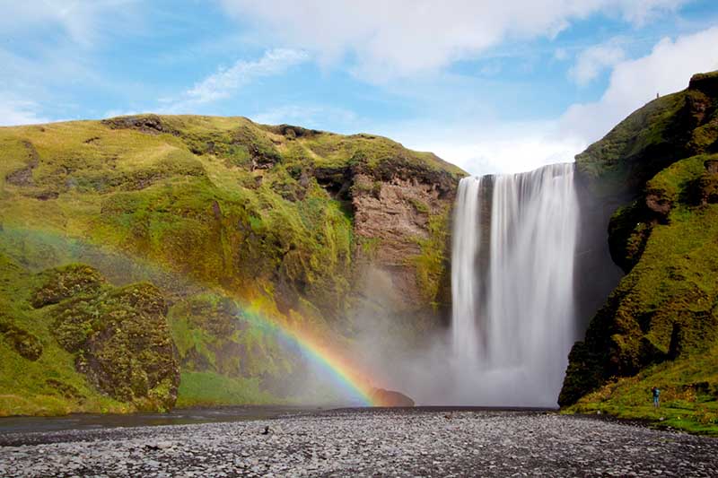
Skógafoss
A short 25-minute drive farther east brings you to Skógafoss, one of Iceland's biggest and most symmetrical waterfalls, dropping 60 meters with a width of 25 meters. Unlike Seljalandsfoss, you approach this giant from its flat base, so you can walk right up to where the thundering spray hits the rocks.
- The viewpoint: To the right of the waterfall, a steep staircase of roughly 520 steps leads to an observation platform overlooking the cascade and the Atlantic Ocean beyond. It is a fantastic leg workout, so take your time, especially when winds are high.
Afternoon: The Dramatic Coastlines of Dyrhólaey and Reynisfjara
Drive distance: about 30 km (Skógafoss to Reynisfjara via Dyrhólaey)
Estimated drive time: 35 minutes
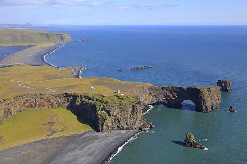
Leaving Skógafoss, the landscape opens into vast glacial outwash plains. Soon you will turn right onto Route 218 toward the Dyrhólaey peninsula.
Dyrhólaey Promontory
Dyrhólaey is a massive 120-meter volcanic arch jutting out into the ocean. From the lower parking area, you can look westward along an endless stretch of black sand coastline. If you are driving a 4x4 and the weather permits, you can climb the steep, unpaved winding road to the upper parking area by the historic lighthouse for a breathtaking 360-degree panorama.
- Seasonal note: Dyrhólaey is a critical nesting ground for Atlantic puffins. The area is subject to strict access restrictions or closures during the breeding season, typically mid-May to late June.
Reynisfjara Black Sand Beach
Returning to Route 1, drive a few minutes east and turn down Route 215 to reach Reynisfjara. This is arguably the most famous black sand beach in the world, known for its stark jet-black volcanic sands, the massive stepping-stone basalt columns (Garðar), and the Reynisdrangar sea stacks rising like jagged teeth from the ocean.
- Critical safety warning: Reynisfjara is beautiful but dangerous. The beach is infamous for sneaker waves, sudden and massive swells that surge much higher up the sand than the waves before them. These waves carry an immense undertow capable of sweeping adults out into the freezing water.
- The golden rules: Never turn your back on the ocean. Keep at least 30 meters from the water line. Stay well clear of the surf zone, and strictly obey the warning lights and signs at the entrance to the beach.
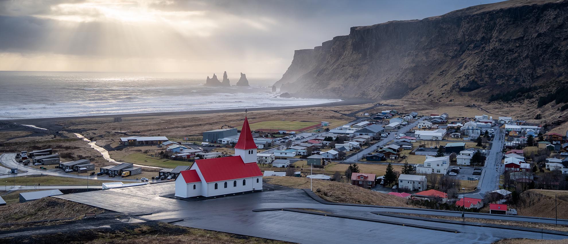
Evening: Settling in the Coastal Village of Vík
Drive distance: about 10 km (Reynisfjara to Vík í Mýrdal)
Estimated drive time: 10 minutes
Wrap up your first day by driving over the mountain ridge into Vík í Mýrdal, a picturesque coastal village. Crowned by a red-roofed church on a hill, Vík is the perfect place to rest overnight. The village offers excellent local restaurants serving fresh Icelandic lamb and seafood, a modern supermarket, and gas stations to top off your fuel tank.
Day 2: Glacial Tongues, Ice Lagoons, and the Return Journey
Morning: Driving the Vast Plains to the Realm of Vatnajökull
Drive distance: about 140 km (Vík to Jökulsárlón)
Estimated drive time: 1 hour 45 minutes
Day two calls for an early start, because you will be crossing some of the most expansive and surreal landscapes Iceland has to offer. Heading east from Vík, you cross the Mýrdalssandur black sand desert, a flat, hauntingly beautiful expanse formed by catastrophic glacial floods from the subglacial Katla volcano.
Next, you wind through the Eldhraun lava field, the largest lava flow from a single eruption in historic times, the 1783 Laki eruption. Today this jagged lava field is completely blanketed by a thick, velvety layer of bright green wool-moss.
Local driving tip: There are dedicated, well-marked pull-offs along Route 1 to view Eldhraun safely. Never pull your car directly onto the shoulder of the highway, and never step onto the moss itself. It is extremely fragile and can take decades to recover from a single footprint.
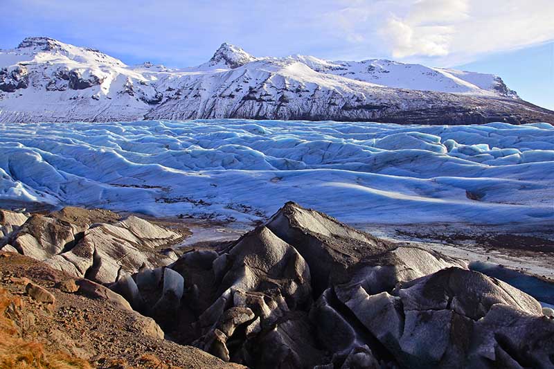
As you pass the historic settlement of Kirkjubæjarklaustur, the massive dome of the Vatnajökull glacier, the largest ice cap in Europe, begins to dominate the northern horizon.
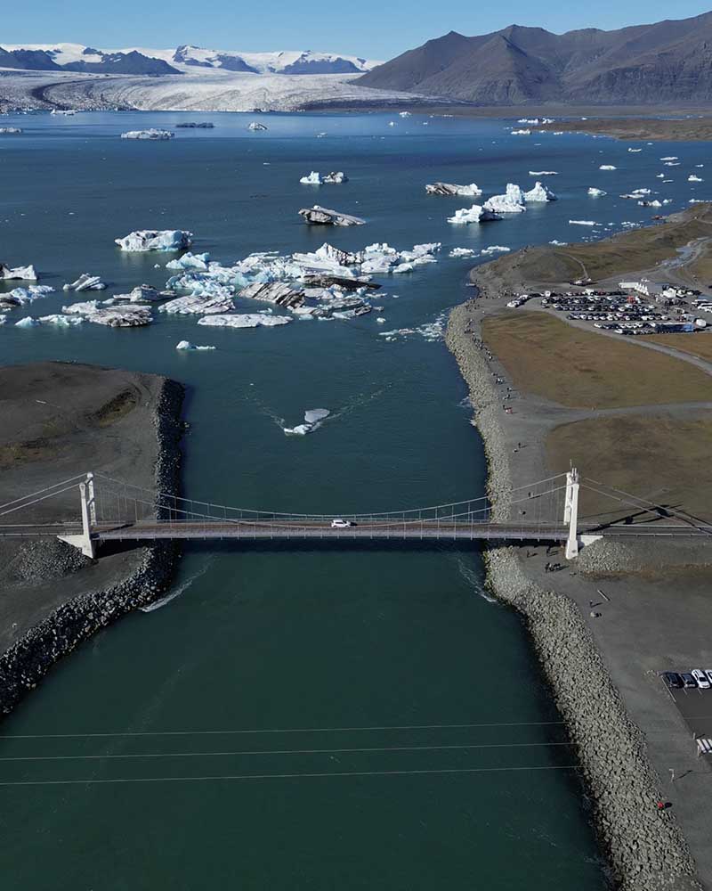
Late Morning: Jökulsárlón Glacier Lagoon and Diamond Beach
Drive distance: about 0 km (the sights sit directly across the road from each other)
Arriving at Jökulsárlón, you will quickly see why it is considered the crown jewel of the South Coast. Here, massive icebergs calve off the Breiðamerkurjökull glacier tongue and float serenely across a deep, 200-meter lagoon before drifting out to sea.
- The experience: Park your vehicle in the primary lot and walk along the shoreline. The silence of the lagoon is broken now and then by the deep, booming crack of an iceberg flipping in the water. You can often spot curious harbor seals swimming among the blue-tinted ice.
- Summer activity: From May to September, you can book a zodiac or amphibian boat tour to navigate directly between the towering icebergs.
- Winter activity: Winter opens access to spectacular crystal ice caves formed within the adjacent glacier, reached by guided tours that depart directly from the Jökulsárlón parking lot.
Diamond Beach (Breiðamerkursandur)
Directly across Route 1 from the lagoon, walk over to the black sand beach where the ocean tide washes the icebergs back onto the shore. The contrast of crystal-clear, polished ice blocks sparkling like diamonds against pitch-black volcanic sand is a photographer's dream.
Afternoon: Svínafellsjökull or Skaftafell Nature Reserve
Drive distance: about 55 km (Jökulsárlón back west to Skaftafell)
Estimated drive time: 45 minutes
After enjoying the glacier lagoon, it is time to begin your return journey westward. But your glacial exploration is not quite finished. Stop at the Skaftafell area, located within Vatnajökull National Park.
Depending on your energy levels and the time of year, you have two excellent options:
- The short glacier view (Svínafellsjökull): A short drive down an unpaved road leads to a parking area where a brief, 15-minute walk brings you right to the edge of an imposing, dirt-streaked glacial tongue. It is an immediate, powerful look at raw ice formations. A 4x4 vehicle makes this unpaved access road much more comfortable.
- The waterfall hike (Svartifoss): If you prefer a leg stretch, park at the main Skaftafell Visitor Center and take the 1.5-hour round-trip hike to Svartifoss. This waterfall is famous for its dramatic backdrop of dark, hanging basalt columns that inspired the architecture of Reykjavík's Hallgrímskirkja church.
Late Afternoon to Evening: The Return West
Drive distance: about 320 km (Skaftafell back to Reykjavík)
Estimated drive time: 4 hours
The drive back to Reykjavík from Skaftafell covers roughly 320 kilometers. It is the same road you drove on Day 1, but seeing the landscape from the opposite direction reveals entirely new angles of the mountains, cliffs, and coastline.
Because this drive takes around four hours without major stops, it is important to manage your energy:
- Plan a dining stop: Break up the journey with dinner in Kirkjubæjarklaustur, Vík, or Selfoss.
- Fuel strategy: Top up your tank before entering the long stretches between Kirkjubæjarklaustur and Vík, where gas stations are less frequent.
- Driver fatigue: In summer, the midnight sun gives you endless daylight, but do not let it trick your body into driving past the point of exhaustion. In winter, plan your departure early enough so you are not navigating the mountain passes near Reykjavík in complete darkness during heavy snowfall.
Smart Adjustments: What to Skip on a 2-Day Timeline
The biggest mistake travelers make along the South Coast is trying to pack every attraction they have seen on social media into a tight 48-hour schedule. That leads to rushed visits, driver exhaustion, and compromised safety.
To keep your 2-day self-drive safe and genuinely enjoyable, we recommend skipping the following sights unless you plan to extend your trip.
The DC-3 Plane Wreck at Sólheimasandur
The skeletal remains of this 1973 US Navy aircraft on a black desert are iconic, but visiting requires parking off Route 1 and walking an 8-kilometer (5-mile) round trip across a flat, wind-swept gravel plain. This walk takes at least 2 to 2.5 hours out of your day. On a tight 2-day winter itinerary, that consumes a huge portion of your remaining daylight, which is better spent at the glacier lagoon.
Deep Exploration of F-Roads or the Highlands
Turning inland onto roads marked with an F, like F208 toward Landmannalaugar, takes you into the rugged, unpaved interior. These routes require specialized heavy-duty 4x4 vehicles, river crossings, and much slower driving speeds. Mixing the Highlands into a 2-day South Coast run is unrealistic and unsafe.
Vestmannaeyjar (The Westman Islands)
Taking the ferry from Landeyjahöfn to the Westman Islands is an incredible experience, but the ferry logistics, waiting times, and island exploration deserve a full dedicated day. Save this for a longer, multi-day Icelandic adventure.
Essential South Coast Driving Rules and Safety Practices
Driving in Iceland is a real joy, provided you understand the local road rules and environmental conditions. Here are the core safety fundamentals every self-drive traveler should follow.
Check Road and Weather Reports Daily, Even Hourly
Icelandic weather changes with extreme speed. Before setting out each morning, and ideally again at lunch, check two primary local resources:
- SafeTravel.is: The leading portal for safety alerts, weather warnings, and travel conditions.
- Road.is (the Icelandic Road and Coastal Administration): Live, color-coded maps showing exact road conditions, such as wet, icy, snow-covered, or closed, plus real-time wind speeds along the South Coast.
Pay Attention to Wind Speeds
Along the South Coast, especially near the mountains of Eyjafjöll and the plains of Mýrdalssandur, localized gusts can grow powerful enough to push vehicles off course or rip car doors clean off their hinges.
- The threshold: Wind speeds are measured in meters per second (m/s). If steady winds or gusts exceed 15 to 20 m/s, exercise extreme caution, particularly in a high-profile SUV. If gusts exceed 25 m/s, it is wise to stay put and wait for the weather to clear.
- The door grip: Whenever you park, hold the car door firmly with both hands when opening it. Open it slowly, bracing against the wind direction so a gust cannot catch it.
Respect Single-Lane Bridges
As you drive east past Vík toward Jökulsárlón, you will encounter several historic single-lane wooden and concrete bridges spanning glacial rivers. The rule is simple: the vehicle closer to the bridge has the right of way. Slow down significantly as you approach and assess whether an oncoming vehicle is already entering or preparing to enter from the opposite side. If it is, pull safely to the right into the designated space and wait for it to pass.
Absolutely No Off-Road Driving
In Iceland, off-road driving is strictly illegal and subject to massive fines reaching thousands of dollars. The volcanic soil and Arctic moss are incredibly fragile, and a single set of tire tracks can scar the landscape for generations. If a parking area is full or an access road looks impassable, do not create your own path. Stick exclusively to marked, designated tracks and roads.
Frequently Asked Questions
Is a 4x4 vehicle required for a 2-day South Coast road trip?
A 4x4 is not legally mandatory if you stay strictly on the main Ring Road (Route 1) during the summer season (May to September), when a standard 2WD vehicle is perfectly capable. However, a 4x4 is highly recommended in the winter months (October to April) to safely handle unpredictable snow, black ice, and strong winds, and it is required year-round if you plan to access any unpaved secondary interior roads.
How many hours of driving does this 2-day itinerary involve?
On Day 1, you will drive roughly 170 kilometers from Reykjavík to Vík, about 2.5 hours of pure driving spread across the day. On Day 2, you will drive from Vík to Jökulsárlón and back to Reykjavík, covering roughly 460 kilometers, or about 5.5 to 6 hours behind the wheel. Total driving time for the trip is around 8 to 8.5 hours.
Can I see the Northern Lights along the South Coast?
Yes. If you are traveling between September and April, the South Coast offers spectacular opportunities to view the Aurora Borealis thanks to its low light pollution. Towns like Vík and the areas around Skaftafell make excellent viewing bases. You will need a clear sky, solar activity, and a dark night. Always check the aurora forecast on SafeTravel.is or the local meteorological site before heading out.
What should I do if a severe weather warning is issued during my trip?
If SafeTravel.is or the Icelandic Meteorological Office issues a yellow, orange, or red weather warning for the South Coast, modify your plans immediately. Do not try to outrun the storm. Stay at your current accommodation or find a safe town center, such as Selfoss, Kirkjubæjarklaustur, or Vík, and wait out the conditions. Your safety is infinitely more important than ticking off every item on your itinerary.
Are there plenty of gas stations and charging points along the South Coast?
Yes, the South Coast is well served by modern fueling stations. Major towns like Selfoss, Hvolsvöllur, Vík, and Kirkjubæjarklaustur have full-service stations with fuel, EV charging bays, restrooms, and hot food. As you head east of Kirkjubæjarklaustur toward Jökulsárlón, the distances between stations grow longer, so it is a good habit to never let your fuel tank or battery charge drop below one-quarter full.
Secure Your Icelandic Road Trip Freedom
A 2-day self-drive journey along Iceland's South Coast is an unforgettable experience that puts you directly in touch with the raw, untamed beauty of the North Atlantic. By choosing the right vehicle, respecting local weather realities, and pacing your schedule wisely, you set yourself up for an adventure that is both thrilling and entirely secure.
At Höldur Car Rental, we are dedicated to providing the reliable foundation your Icelandic road trip requires. As the country's exclusive Europcar franchisee, we offer a modern, diverse fleet ranging from nimble city cars to larger 4x4 SUVs, backed by an unmatched support network across the island.
Ready to experience the freedom of the open Icelandic road?
